Moby Dex at FOSSGIS

Dr. Christopher Frank from CISS TDI GmbH represented Moby Dex at FOSSGIS 2026 in Göttingen. FOSSGIS 2026 provided Moby Dex with the opportunity to present the project within the open-source GIS community and to deepen the technical exchange on geodata, QGIS, and data-driven infrastructure planning. The visit to Göttingen was characterized by numerous conversations with experts from practice, science, and administration and provided valuable impulses for further project work.
As part of the poster exhibition, the contribution “Potentialflächenanalyse für Radwege: Erweiterung eines QGIS-Plugins für Wind- und PV”1 was presented on March 26, 2026. In the Moby Dex project, the open QGIS plugin for white space mapping for wind and PV installations is being adapted and extended for cycle path planning. The goal is to evaluate road sections along existing infrastructure based on open geodata with regard to their potential for cycle lanes, protected lanes, and separate cycle paths.
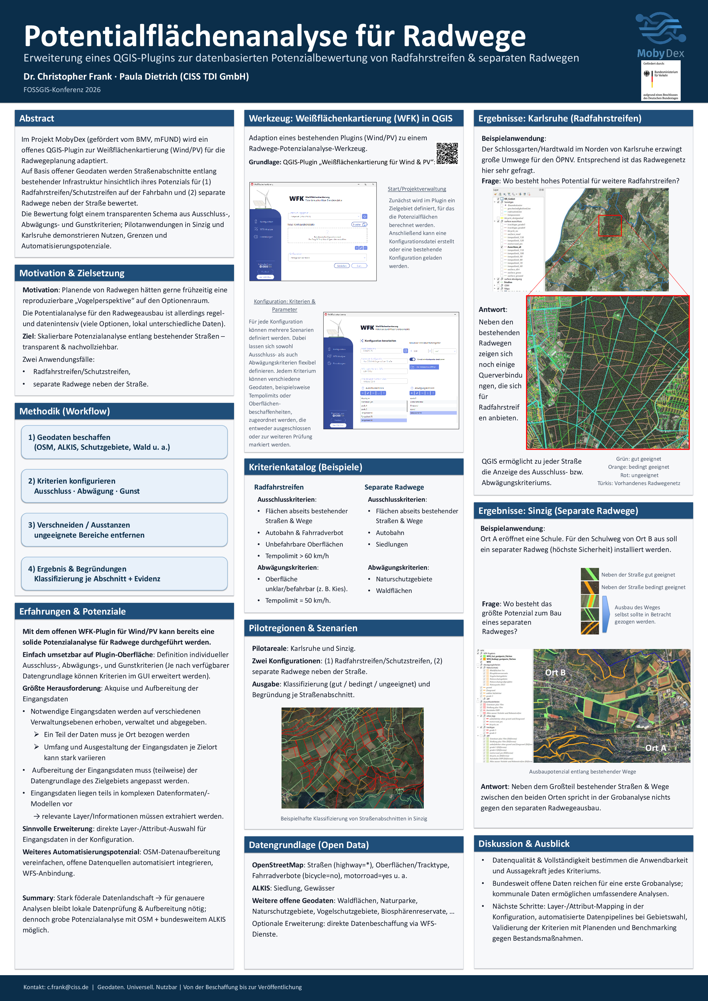
The methodology follows a transparent scheme of exclusion, weighing, and preference criteria. Among other things, road characteristics, available areas, protection areas, and other open geodata sources are taken into account. The QGIS plugin is intended to enable a scalable and reproducible analysis of potential sites for Bicycle Paths and thus support data-driven planning processes.
On the poster, experiences from the pilot regions of Sinzig and Karlsruhe were also presented. They show that the adapted tool already enables a reliable coarse analysis, while the quality and availability of local input data remain crucial for the accuracy and depth of the assessment.
Particularly valuable was the numerous positive feedback from cities and municipalities. The feedback confirmed that there is high practical demand for data-driven and traceable tools to support cycle traffic planning. In addition, concrete suggestions for useful extensions of the currently considered weighting criteria emerged from the discussions.
Thus, the visit to FOSSGIS 2026 not only strengthened Moby Dex’s visibility in the open-source environment, but also provided valuable technical impulses for further project work. Many thanks to the participants and organizers of FOSSGIS.
1 Analysis of Potential Sites for Bicycle Paths: Extension of a QGIS Plugin for Wind and Solar Power
This text was machine translated from German to English using the LLM Qwen-Coder-Next 80b.